From a few semesters ago, atmospheric pressure crushing power.
Nice.
Showing posts with label pressure. Show all posts
Showing posts with label pressure. Show all posts
Tuesday, March 22, 2011
Thursday, February 17, 2011
Solar flare, space weather report
 You can read up on recent solar flare activities, and how we measure them out here on Earth's orbit, if you click through to the Space Weather Prediction Center, operated by NOAA. It's got an interesting speedometer for the solar wind, as well as a pressure gauge.

Friday, April 16, 2010
Convection in the surface of our star.
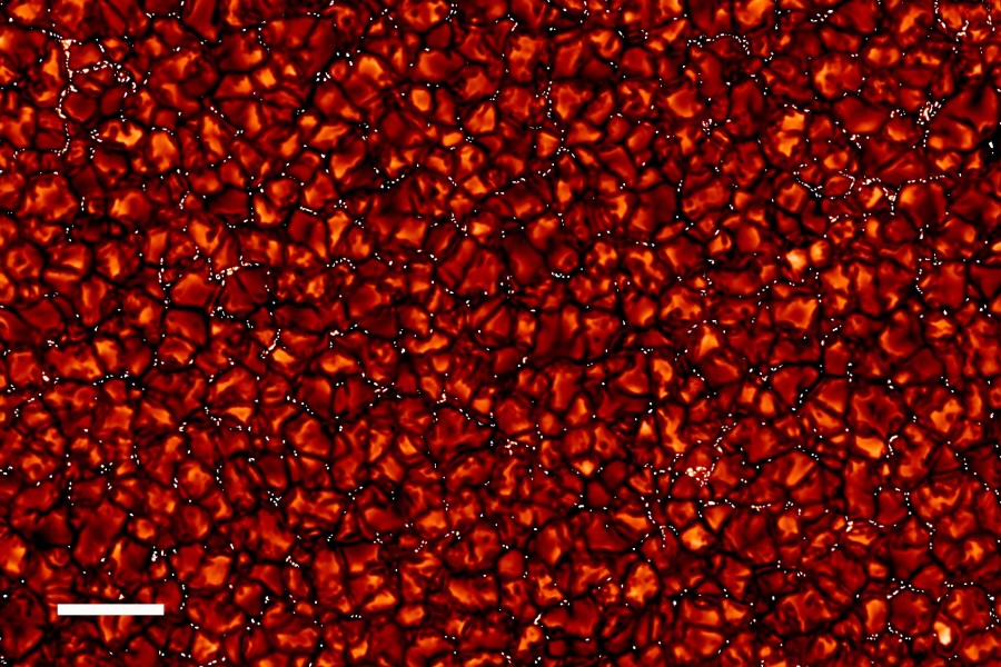
In Astronomy Picture of the Day for April 16: Convection cells in the surface of our star.
Up close, the solar surface is a striking patch work of granules in this very high resolution picture of the quiet Sun. Caused by convection, the granules are hot, rising columns of plasma edged by dark lanes of cooler, descending plasma. But the high-resolution view reveals that the dark lanes are dotted with many small, contrasting bright points. Constantly present on the solar surface, the bright points do not seem to be related to sunspots that come and go with the magnetic solar cycle. Nonetheless, the bright points are regions of concentrated magnetic fields and are bright because the magnetic pressure opens a window to hotter deeper layers below the photosphere. For scale, the white bar at the lower left corresponds to 5,000 kilometers across the Sun's surface. The sharp, narrow-band image was recorded in September, 2007 using the Swedish Solar Telescope on the astronomical island of La Palma.For comparison, 5000 kilometers in solar diagram vs. 4100 km from Orlando to Seattle:

Nice.
Sunday, April 11, 2010
Extremely cool pressure suit and deliberately jumping out of a perfectly good airplane.
Sweet gear. 
Skydiving is dangerous -- but not nearly as dangerous as skydiving from a plane in outer space.
That can kill you. The temperature can freeze your body, and the lack of air pressure can boil your blood.
Nonetheless, an Austrian daredevil named Felix Baumgartner plans to take the 23-mile plunge from the edge of space. And in the process, he hopes to become the first parachutist to break the sound barrier, plummeting toward the ground at 760 miles per hour.
(By John R. Quain - FOXNews.com)
Wednesday, October 31, 2007
996
 Check out this public advisory for Tropical Storm Noel. See how low the central pressure is? How does that compare to fair weather at sea level? |
| 000 WTNT31 KNHC 312032 TCPAT1 BULLETIN TROPICAL STORM NOEL ADVISORY NUMBER 17 NWS TPC/NATIONAL HURRICANE CENTER MIAMI FL AL162007 500 PM EDT WED OCT 31 2007 ...NOEL LINGERING ALONG THE CUBAN COAST...TROPICAL STORM WATCH ISSUED FOR THE SOUTHEAST FLORIDA COAST... AT 5PM EDT...2100Z...A TROPICAL STORM WATCH IS IN EFFECT FROM NORTH OF OCEAN REEF TO JUPITER INLET FLORIDA. A TROPICAL STORM WATCH MEANS THAT TROPICAL STORM CONDITIONS ARE POSSIBLE WITHIN THE WATCH AREA. A TROPICAL STORM WARNING REMAINS IN EFFECT FOR THE CUBAN PROVINCES OF SANCTI SPIRITUS...CIEGO DE AVILA...CAMAGUEY...LAS TUNAS... GRANMA...HOLGUIN...SANTIAGO DE CUBA...AND GUANTANAMO. A TROPICAL STORM WARNING REMAINS IN EFFECT FOR THE CENTRAL AND NORTHWESTERN BAHAMAS. FOR STORM INFORMATION SPECIFIC TO YOUR AREA...INCLUDING POSSIBLE INLAND WATCHES AND WARNINGS...PLEASE MONITOR PRODUCTS ISSUED BY YOUR LOCAL WEATHER OFFICE. AT 500 PM EDT...2100Z...THE CENTER OF TROPICAL STORM NOEL WAS LOCATED NEAR LATITUDE 22.6 NORTH...LONGITUDE 78.8 WEST OR ABOUT 190 MILES...305 KM...SOUTH-SOUTHWEST OF NASSAU AND ABOUT 240 MILES...385 KM...SOUTH-SOUTHEAST OF MIAMI FLORIDA. NOEL HAS BEEN STATIONARY FOR THE LAST SEVERAL HOURS...BUT A GENERALLY NORTHWARD MOTION IS EXPECTED OVER THE NEXT 24 HOURS. MAXIMUM SUSTAINED WINDS ARE NEAR 50 MPH...85 KM/HR...WITH HIGHER GUSTS. SOME STRENGTHENING IS FORECAST DURING THE NEXT 24 HOURS. TROPICAL STORM FORCE WINDS EXTEND OUTWARD UP TO 115 MILES...185 KM FROM THE CENTER. ESTIMATED MINIMUM CENTRAL PRESSURE IS 996 MB...29.41 INCHES. ABOVE NORMAL TIDES ARE LIKELY WITHIN THE WARNING AREAS. |
Subscribe to:
Posts (Atom)